The Old Print Shop, Inc is pleased to announce it is exhibiting in the Miami International Map Fair, February 5-7, 2016. The map fair is held at History Miami 101 West Flagler Street, Miami, FL 33130 and is open to the public Saturday February 6, 10 am to 5 pm and Sunday February 7 from noon to 5 pm. There is a preview party for registered guests on Friday February 5 from 6 to 9 pm. Click Here to go to the Miami International Map Fair web site with links to register for the opening event.
The Old Print Shop will be featuring a wonderful collection of early printed maps including maps of the world, eastern United States, areas of new discoveries in the seventeenth and eighteenth centuries and a nice collection of city views. Below are listed a few highlights;
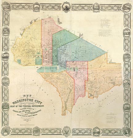
“Map of Washington City / District of Columbia . . . .” Surveyed and published by A. Boschke, 1857. Stone engraving and lithograph by J. Bien. Albert Boschke was a German (or Polish) born civil engineer who worked for U.S. Coast and Geodetic Survey in Washington, DC. On his own he conceived the idea of making a highly accurate map of Washington and of the District of Columbia with the hope of selling to the Government and privately. At his own expense he organized and employed a group of surveyors to do the fieldwork. This is one of the two maps produced from his surveys it is a four sheet wall map 58 1/4 x 56 3/4". The map was considered the most accurate of any produced of the city with a scale of 500 feet to the inch, showing both private properties and government facilities. This is likely why the map is so rare, most copies were destroyed by the US Government at the onset of the Civil War. CLICK HERE for a full description on our web site.
“To His Excellency Sr. Henry Moore, Bart., captain general and governour in chief in & over the province of New York & the territories. . . this plan of the city of New York is most humbly inscribed by His Excellency's most obedient servant, Bern'd Ratzen.” Bernard Ratzer. Copper plate engraving, 1766-67. A rare first state of one of the most important eighteenth-century maps of New York City. “Made just prior to the Revolution, the Ratzen plan is the most accurate and useful survey of New York then circulating.” Deak. The plan shows the topography and existing streets, avenues, estates, farmlands, wharfs, and forts. A small portion of Brooklyn, here entitled “Part of Long or Nassau Island” is shown with the important “Brookland Ferry” indicated. A numbered key identifies thirty-one public buildings, churches, and markets. CLICK HERE for a full description on our web site.

“Maris Pacifici, (quod vulgo Mar del Zur) cum regionibus circumiacentibus, insulisque in eodem passim sparsis, novissima descriptio.” Abraham Ortelius. Copper plate engraving, 1589. One of the most important maps published in the Ortelius atlas, as well as the first available printed map to be devoted to the Pacific Ocean. Circumnavigator Ferdinand Magellan's ship, "Victoria," is shown in the lower right off the coast of South America. CLICK HERE for a full description on our web site.


 Login / Register
 Basket