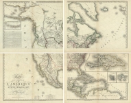
ARTIST: Adrien Hubert Brue
MEDIUM: Engraving,
DATE: 1822
EDITION SIZE: 19 3/4 x 14 1/4" (501 x 362 mm) plus margins.
DESCRIPTION: A well engraved and highly detailed map of Mexico, California and the general Southwest. Nice post Humboldt-Pike-Long cartography in the Rocky Mountains and Plains. Excellent detail in Texas, which is named, but without sign of the Austin Colony. The two Salt Lakes are shown with three possible rivers flowing to the Pacific. This map appeared in a deluxe, heavy paper edition of Brue's "Atlas Universel de Geographie Physique, Politique, Ancienne & Moderne."
ADDITIONAL INFO:
CONDITION: Very good condition. Original outline hand coloring.
REFERENCE: Wheat 361


 Login / Register
 Basket