ARTIST: F. W. Beers
PUBLISHER: Published by R. T. White & Co. NY.
MEDIUM: Handcolored stone engraving,
DATE: 1876.
EDITION SIZE: Image size 14 1/8 x 11 1/8" (33.5 x 28 cm)
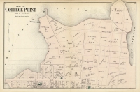
DESCRIPTION: A handsome map of the township that appeared in "County Atlas of Berkshire Massachusetts." by F. W. Beers. Showing proposed railroad, roads, lakes & rivers, mountains, schools, businesses etc. Homes and owners names are given.
ADDITIONAL INFO:
CONDITION: Overall good condition with original color. Minor offset.
REFERENCE:


 Login / Register
 Basket

![Adams. [and] Hancock. [Towns of].](https://oldprintshop.com/uploads/jpg/24298_productthumb.jpg)