ARTIST: Thomas Jefferys
PUBLISHER: Published by Robert Sayer, map and print seller, London.
MEDIUM: Copper plate engraving,
DATE: 1775.
EDITION SIZE: 12 5/8 x 18 1/4" (324 x 464 mm) plus title and margins.
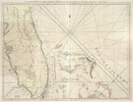
DESCRIPTION: A beautiful and finely engraved map of the island from Tho. Jeffreys' "The West Indian Atlas". Bequia is a small island about an hour by ferry from St. Vincent. This chart depicts Admiralty or North Bay, South East Bay, Ance Hyby, Bay Salabin, Northeast Point, Grande Ance, West Point & South East Bay. A few roads and buildings are noted.
ADDITIONAL INFO:
CONDITION: Good condition. Black & white.
REFERENCE:


 Login / Register
 Basket