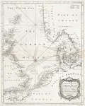
ARTIST: Richard Seale
MEDIUM: Copper plate engraving,
DATE: c.1764.
EDITION SIZE: 15 x 18 3/4" (381 x 477 mm) plus margins.
DESCRIPTION: Very detailed map of Baltic Sea. Inset map shows the harbor of St. Petersburg.This map appeared in "Mr. Tindal's continuation of Mr. Rapin's History."
ADDITIONAL INFO:
CONDITION: Good condition save for faint staining along upper centerfold. Black & white.
REFERENCE:


 Login / Register
 Basket