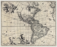
ARTIST: John Ogilby
PUBLISHER: Published by Ogilby, White Fryers, London.
MEDIUM: Copper plate engraving,
DATE: 1671
EDITION SIZE: Image size 11 3/8 x 13 7/8" (290 x 351 mm).
DESCRIPTION: This map is derived from Capt. John Smith's landmark 1612 map of Virginia, based upon the Hondius-Blaeu versions. It depicts the entire Chesapeake Bay area including its major tributaries. The Montanus map is identical to the Ogilby map of the same year. Both are renowned for the cartouche depicting a Brazilian Indian with a llama, goat, and unicorn.
ADDITIONAL INFO: This example has additional manuscript title information, likely from the publisher or early owner. "Terrae Mariae Nova et Virginiae Tabula."
CONDITION: Good condition. Black & white.
REFERENCE: Smith's Virginia and Its Derivatives, deriv. 8; Burden, "North America" 413.


 Login / Register
 Basket