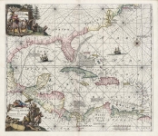
ARTIST: Louis Renard
PUBLISHER: Published by L. Renard, Amsterdam.
MEDIUM: Copper engraving.
DATE: 1715.
EDITION SIZE: Image size 19 x 21 7/8 (483 x 558 mm)
DESCRIPTION: A fine seachart of the Pacific coast from Mexico south through Chile, after De Witt. Part of the Caribbean is shown as well.This chart is a good example of Renard's decorative skill, with an elqaborate title cartouche, ships at sea and compass roses. From"Atlas de la Navigation et du Commerce."
ADDITIONAL INFO:
CONDITION: Good condition save repaired lower centerfold and light stain in upper right corner. Black and white.
REFERENCE:


 Login / Register
 Basket