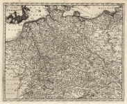
ARTIST: Philip Cluver
PUBLISHER: Published by Johann Pauli, Amsterdam
MEDIUM: Copper plate engraving,
DATE: 1729
EDITION SIZE: 7 7/8 x 10" (201 x 254 mm) plus margins.
DESCRIPTION: Two maps of historical Germany on a single sheet. The two maps appear identical at first glance, but actually are a comparison of the region during the reigns of different Roman Emperors. Both contain strapwork title cartouches. Appeared in "Introductionis in Universam Geographiam...".
ADDITIONAL INFO:
CONDITION: Good condition.
REFERENCE:


 Login / Register
 Basket