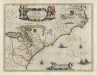
ARTIST: Willem Blaeu
PUBLISHER: Published in Amsterdam.
MEDIUM: Copper engraving,
DATE: c. 1640.
EDITION SIZE: Image size, 15 x 19 5/8" (383 x 498 mm) plus margins.
DESCRIPTION: This handsome map is based upon the cartography of Gerard Mercator, as stated in an inscription in its lower left corner. Mercator’s original 1595 map was enlarged and remade by later mapmakers such as Hondius and Blaeu during the early 17th century. The map depicts this Eastern European region of the Balkans including Slavonia, Croatia, and Bosnia, with the Gulf of Venice at lower left. Regions, mountains, rivers, and towns are labeled. Three coats of arms appear at top center.
ADDITIONAL INFO:
CONDITION: Good condition save for some creasing parallel to the centerfold. Some splitting in upper centerfold. Original color.
REFERENCE:


 Login / Register
 Basket