MEDIUM: Copper plate engraving,
DATE: 1777
EDITION SIZE: Image size, 12 1/2 x 16" (317 x 405 mm) plus margins.
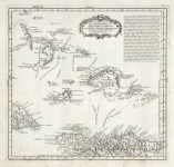
DESCRIPTION: A rare separately issued chart showing the entrance of the Rio Grande de San Pedro in Brazil. Based upon a manuscript chart drawn by Pedro d Elola that drawn in 1777 during the Spanish-Portuguese War. The plan shows the harbor and its defensive fortifications. The map was prepared by Lopez from original manuscript maps and information drawn from the expedition of Pedro Rodriguez Cevallos (November 1776 to August 1777) which Lopez had obtained from the Real Academia de la Historia (Madrid). Tomas Lopez, was the official cartographer to the King of Spain during the second half of the eighteenth century.
ADDITIONAL INFO:
CONDITION: Good condition. Black & white.
REFERENCE:


 Login / Register
 Basket