ARTIST: Ormando Gray
PUBLISHER: Published by Philadelphia: O.W. Gray & Son.
MEDIUM: Stone engraving,
DATE: 1877
EDITION SIZE: Image size 12 x 14 7/8" (303 x 378 mm) plus margins.
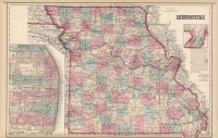
DESCRIPTION: A decorative and well engraved map of Nebraska from Gray's National Atlas. Nicely detailed, showing railroad lines, towns, villages and rivers. The eastern part of the state is developed. The north west corner is identified only as "Sioux"
ADDITIONAL INFO:
CONDITION: Good condition, original hand coloring.
REFERENCE:


 Login / Register
 Basket