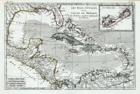
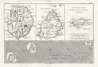
ARTIST: Rigobert Bonne
MEDIUM: Copper engraving, hand colored,
DATE: c. 1780.
EDITION SIZE: Image size 12 5/8 x 8 1/2" (323 x 213 mm).
DESCRIPTION: An attractive map of the Lesser Antilles with nine indiivdual island maps below the top map of the Virgin Islands. Depicted are Barbuda, St. Kitts, Antigua, Dominica, Santa Lucia, Barbados, St. Vincent, Grenada and Tobago. From Bonne's " Atlas de Toutes les Parties Connues du Globe".
ADDITIONAL INFO:
CONDITION: Good condition with modern hand color.
REFERENCE:


 Login / Register
 Basket