PUBLISHER: Published by D' Après de Mannevillette, Paris.
MEDIUM: Copper plate engraving,
DATE: c.1775
EDITION SIZE: Image size 18 7/8 x 13 1/8" (479 x 335 mm) plus margins.
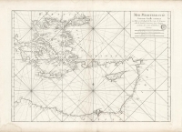
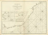
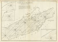
DESCRIPTION: A fine sea chart of the Cape Verde islands. Jean Baptiste D' Après de Mannevillette (1707-1780) was a sailor, mathematician and hydrographer. His father was a Captain in the “Campagnie des Indes” or French East India Company. Recognizing the poor quality of charts published for the route to the Far East thus far, Mannevillette set out to upgrade them. During the mid 1730’s he collected data and updated charts which culminated in 1745 with the issuance of “Le Neptune Oriental” which comprised of 22 charts. This work was quickly recognized as being a great advancement over all earlier works. During the remainder of his life Mannevillette continued to update and add new information and in 1775 issued an enlarged edition containing 63 charts. This new edition contained many charts that were based on information collected by Alexander Dalrymple, a Scottish geographer (and later the first hydrographer of the British Admiralty.
ADDITIONAL INFO:
CONDITION: Good condition save for some faint damp staining in the upper left. B/W
REFERENCE:


 Login / Register
 Basket