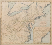
ARTIST: John Stockdale
PUBLISHER: Published by Issac Weld, London.
MEDIUM: Copper plate engraving,
DATE: 1798
EDITION SIZE: 16 x 18 1/4" (405 x 464 mm) plus margins.
DESCRIPTION: A fine map of the eastern part of the United States with an inset map of Georgia and South Carolina. The map covers from the “Province of Main” southward to the North & South Carolina border, with a continuation inset of South Carolina south to the St. Mary’s River. Notes of the Western Territory (Ohio and Indiana) and Kentucky. The villages of "Christian Indians" are located.
ADDITIONAL INFO:
CONDITION: Good condition save for some professionally repaired splits along fold lines. Black & white.
REFERENCE: McCorkle, "New England" #798.5


 Login / Register
 Basket