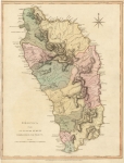
ARTIST: Thomas Jefferys
PUBLISHER: Published by Laurie & Whittle, No. 53 Fleet Street, London
MEDIUM: Copper plate engraving,
DATE: 1775-1794
EDITION SIZE: Image size 18 3/8 x 24 1/4" (462 x 616 mm).
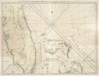
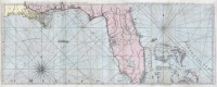
DESCRIPTION: This is a beautiful and finely engraved map of the island of Jamaica that first appeared in Thomas Jeffreys' "The West Indian Atlas," a detailed description of the West Indies including charts and historical accounts based on surveys conducted during that time. This map includes names of towns and geographic landmarks, and shows anchorages, soundings along the coast, rivers, and roads. The upper left corner includes the annotation "The Negro-towns are Distinguished by a Stroke under the Name.” Insets in the lower left and right corners show the Harbor of Bluefields and the Harbors of Kingston and Port Royal, depicted in detail including coastal soundings and the names of some plantations.
ADDITIONAL INFO: An unusual example of this map with full period hand color.
CONDITION: Good condition save for some splitting along centerfold. Full original hand coloring.
REFERENCE:


 Login / Register
 Basket