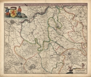
ARTIST: Frederick de Wit
MEDIUM: Copper plate engraving,
DATE: c.1680.
EDITION SIZE: Image size 16 3/8 x 19 3/4" (416 x 500 mm) plus margins.
DESCRIPTION: A nice example of De Wit's map of Estonia and Lithuania and parts of Russia.
ADDITIONAL INFO:
CONDITION: Very good condition. Original outline color.
REFERENCE:


 Login / Register
 Basket