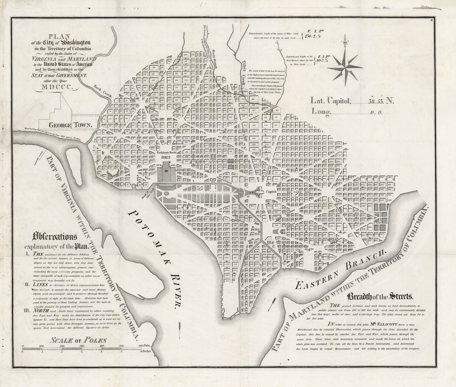
ARTIST: Andrew Ellicott
PUBLISHER: Originally engraved by Samuel Hill, re-engraved and Published by the U.S. Coast and Geodetic Survey.
MEDIUM: Engraving,
DATE: 1792. (c.1900).
EDITION SIZE: 16 1/2 x 20 1/4" (42.7 x 51.5 cm) plus margins.
DESCRIPTION: On January 24, 1791, President George Washington announced the Congressionally designated permanent location of the national capital, a diamond-shaped ten-mile tract at the confluence of the Potomac and Eastern Branch Rivers. The original survey of the 100 square mile diamond shaped "district" was undertaken by Andrew Ellicott and Benjamin Banneker (a free slave). In March of 1791, Major Pierre Charles L'Enfant was appointed by George Washington to prepare the plan for the city itself with Ellicott as his assistant. Unfortunately, L'Enfant turned out to be very difficult to work with. Eventually both Washington and Jefferson became disgusted with L'Enfant's obstinacy which led to his being suspended in 1792 and outright termination in 1793. Ellicott took over the project using L'Enfants plan as a base. The Philadelphia engravers, James Thackera & John Vallance and Samuel Blodget Jr. were hired to produce engraved versions. Blodget arranged for Samuel Hill of Boston to engrave the map for him. Both Hill and Thackera & Vallance produced a large "official" map of the new "federal city" as well as two small, almost virtually identical maps. This is the large Samuel Hill or "Boston" plan. This plan has the distinction of being printed one month earlier then the "Philadelphia" plan. The Hill plan is known as rarer of the two. An important and rare plan of the nations capitol.
ADDITIONAL INFO: A fine impression.
CONDITION: Good condition. Repaired tear in upper left from tab. B/W
REFERENCE: Verner, 4; Wheat & Brun, 530.


 Login / Register
 Basket