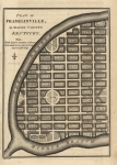
ARTIST: J. Russell
PUBLISHER: Published by H. D. Symonds, London.
MEDIUM: Copper plate engraving
DATE: 1794-95
EDITION SIZE: 6 3/8 x 4 5/8" (16.1 x 11.7) plus margins.
DESCRIPTION: Plan for a proposed town on the banks of the South Creek of the Rolling Fork of the Salt River. A key in the lower left indicates several town buildings. All streets bear two names. Appeared in the English edition of William Winterbotham's "An Historical View of the United States."
ADDITIONAL INFO:
CONDITION: Good condition. B/W
REFERENCE:


 Login / Register
 Basket