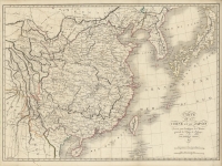
ARTIST: Ambroise Tardieu
MEDIUM: Copper plate engraving,
DATE: 1821.
EDITION SIZE: 15 1/2 x 9 7/8" (39.3 x 25 cm) plus margins.
DESCRIPTION: A fine map of Mexico. Texas and Rocky Mountains. This map shows an area from the Mexico-Guatemala border northward to the Great Salt Lake. Includes both Salt Lake and the mythical lake to its south, with what amounts to a continuation of the Rio de San Buenaventura extending eastward. Texas is named with a few cities including San Antonio shown. Louisiane and Nouveau Mexique also appear. Manyl Indian tribes are named.. Appeared in La Harpe's Histoire Generale des Voyages.
ADDITIONAL INFO:
CONDITION: Good condition. Original outline color.
REFERENCE:


 Login / Register
 Basket