ARTIST: Fielding Lucas, Jr.
PUBLISHER: Published by H. C. Carey and I. Lea, Philadelphia.
MEDIUM: Handcolored engraving,
DATE: c.1826.
EDITION SIZE: 16 1/2 x 20 1/2" (419 x 520 mm) including text plus margins.
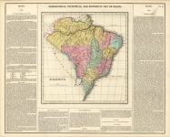
DESCRIPTION: A fine map from Carey and Lea's "A Complete Historical, Chronical, and Geographical American Atlas, . . ." Published in Philadelphia. The text describes the boundaries, climate, rivers, chief towns and a historical "sketch" of the state. Map drawn by F. Lucas, Jr. Engraved by Young & Delleker.
ADDITIONAL INFO:
CONDITION: Fair to good condition. Splitting and short tear along lower centerfold. Minor browning along centerfold.
REFERENCE:


 Login / Register
 Basket


![Geographical, Statistical, and Historical Map of the United Provinces of South America. [Argentina]](https://oldprintshop.com/uploads/jpg/23531_productthumb.jpg)