ARTIST: J. F. W. Des Barres
PUBLISHER: Published by J .F. W. Des Barres, London.
MEDIUM: Etching and aquatint engraving,
DATE: Undated, c.1776.
EDITION SIZE: Sheet size 29 1/2 x 20 3/4" (75 x 52.5 cm)
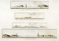
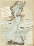
DESCRIPTION: Views of the Hudson River views from the Revolutionary War.<br><br> This fine and rare series of views appeared in some examples of the "Atlantic Neptune" by Captain Joseph Frederick Wallet Des Barres. The "Atlantic Neptune" is one of the finest large-scale sea atlases or pilots ever produced. The Atlantic Neptune focused on the Canadian and United States Atlantic coastlines. The maps and views in this atlas were produced over a seven-year period (1775-82) and are well known for their accurate portrayal of various sounds, bays, bars, and harbors, as well as navigational hazards. This monumental work was used extensively by the Royal Navy during the American Revolution. Occasionally, des Barres included views in the series, usually these views were included as aids for navigation. Sometimes a view of a city was included, New York, Boston, Portsmouth and Halifax were done.<br><br> This series of three views of prominent locations on the Hudson River, Anthony’s Nose and Forts Montgomery and Clinton (on the grounds of current day West Point) which are directly across the river. It is this catalogers believe that the views were produced just before the famous chain was stretched across the river between Fort Montgomery and Anthony’s Nose by the American rebel forces to inhibit the British from sailing north. According to the Royal Museums of Greenwich there are two variants of this plate. Both saw the same scenes but the arrangement of the views is different. Both are also two completely different printing plates. Neither have any engraved titles or information. This view likely appeared in only a few examples of the work as it was likely superseded by the 1779 close up two-part chart “Part of Hudson’s River…. & A Plan of Fort Montgomery & Fort Clinton…” which shows the chain. We consider this view to be rare.
ADDITIONAL INFO:
CONDITION: Good condition save for some faint centerfold glue staining. B/W
REFERENCE:


 Login / Register
 Basket