MEDIUM: Copper plate engraving,
DATE: 1775.
EDITION SIZE: Image size 27 1/8 x 19" (69 x 48.4 cm).
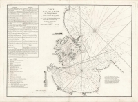
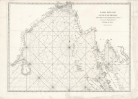
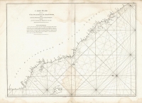
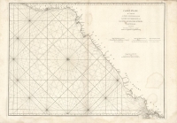
DESCRIPTION: A large sea chart of the Indian Ocean, including extensive rhumb lines and fine detail along the coasts of Africa, Asia, and Australia. Names ports, ocean passages, and islands of various sizes – Madagascar, Borneo, and the Philippines are depicted in particular detail. Parts of Australia’s coast are left open to the ocean, indicating that the coastline was as yet uncharted in those areas.<br><br>Mannevillette was a prominent French hydrographer and cartographer, and a superior officer in the French East India Company. He was known for charting the coasts of India and China during the 18th century. Mannevillette’s work was internationally renowned, and his charts and atlases were important resources for ships navigating the region.
ADDITIONAL INFO:
CONDITION: Good condition. Small imperfection in paper of title.
REFERENCE: Tooley, 57


 Login / Register
 Basket