MEDIUM: Copper plate engraving,
DATE: 1775.
EDITION SIZE: Image size 25 5/8 x 18 3/8" (65 x 46.7 cm).
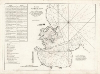
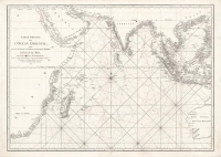
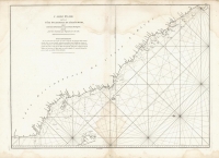
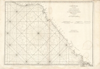
DESCRIPTION: A detailed map of the ocean and coastal areas of the Gulf of Bengal, from the Island of Ceylon to the Gulf of Siam, and part of the straits of Malacca. Includes the coasts of modern-day Cambodia, Thailand, Malaysia, Sumatra, Myanmar, Bangladesh, Sri Lanka, and part of India. This large sea chart includes extensive rhumb lines and fine detail along the coasts, naming ports, ocean passages, and islands of various sizes. <br><br>Mannevillette was a prominent French hydrographer and cartographer, and a superior officer in the French East India Company. He was known for charting the coasts of India and China during the 18th century. Mannevillette’s work was internationally renowned, and his charts and atlases were important resources for ships navigating the region. This map is from the 1775 expanded edition of his atlas “Le Neptune Oriental”, which was an authoritative and widely used source in the late 18th and early 19th centuries, and drew on Mannevillette’s own experience as a navigator and naval officer in the seas of Asia.
ADDITIONAL INFO:
CONDITION: Good condition, save for short repaired tear to plate mark in right margin.
REFERENCE:


 Login / Register
 Basket