MEDIUM: Copper plate engraving,
DATE: c.1775.
EDITION SIZE: Image size 13 x 18 1/2" (33 x 47 cm) plus margins.
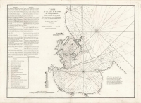
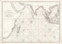
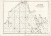
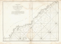
DESCRIPTION: Engraved by Guillaume-Nicolas Delahaye. A fine chart of the archipelago that is the modern-day Seychelles, including islands such as Mahe, Silhouette Island, Praslin, La Digue, Fregate, Felicite, and Curieuse. Notable in this map are its rhumb lines, and soundings in the water between islands. At the time this chart was drawn, the area would have recently entered French jurisdiction; the French controlled the islands for a brief period from 1756 until their capitulation to a 1794 British invasion. The islands were a useful transit point and stopping ground for trade passing between Africa and Asia.<br><br> Jean Baptiste d’Apres de Mannevillette was a prominent French hydrographer and cartographer, and a superior officer in the French East India Company. He was known for charting the coasts of India and China during the 18th century. Mannevillette’s work was internationally renowned, and his charts and atlases were important resources for ships navigating the region. His atlas “Le Neptune Oriental” was an authoritative and widely used source in the late 18th and early 19th centuries, and drew on Mannevillette’s own experience as a navigator and naval officer in the seas of Asia.
ADDITIONAL INFO:
CONDITION: Good condition save for some minor fox marks in the upper right.
REFERENCE:


 Login / Register
 Basket