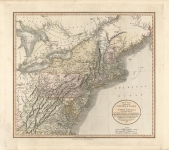
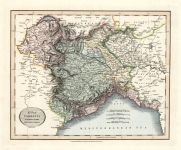
ARTIST: John Cary
PUBLISHER: Published by John Cary, engraver & map seller, 181 Strand, London.
MEDIUM: Engraving, hand colored,
DATE: 1799.
EDITION SIZE: Image 18 x 20 1/4" (45.6 x 51.6 cm) plus margins.
DESCRIPTION: During the Early Modern period the Holy Roman Empire was divided into Imperial Circles, administrative groupings whose primary purposes were the organization of common defensive structure and the collection of imperial taxes. It appeared in Cary's New Universal Atlas.
ADDITIONAL INFO:
CONDITION: Fair condition several tears in the sheet edges, one on the right 1/4" past neat line. Full original hand coloring.
REFERENCE:


 Login / Register
 Basket