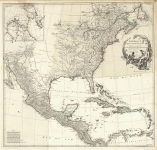
ARTIST: Jean Baptiste D'Anville
PUBLISHER: London, Printed for Robt. Sayer & J. Bennet, Map & Printsellers, No.53 Fleet Street, as the Act directs. 10 June,1775
MEDIUM: Handcolored copper plate engraving,
DATE: 1775.
EDITION SIZE: 18 x 20 1/8" (457 x 511) plus margins.
DESCRIPTION: A map of North America produced just prior to the Revolutionary War. The colonies are shown with the borders determined at the end French and Indian War in 1763. The western borders of many of the colonies is left open (uncolored) and are indicated by a dotted line leaving open the possibility of expansion westward. This map appeared in Thomas Jeffreys "The American Atlas." One of the greatest atlases of America of the time.
ADDITIONAL INFO:
CONDITION: Good condition save for small repaired puncture within image.. Original outline color.
REFERENCE:


 Login / Register
 Basket