ARTIST: Jacques Bellin
PUBLISHER: Published by J. N. Bellin, Paris.
MEDIUM: Copper plate engraving with handcolored outlines,
DATE: 1764
EDITION SIZE: Image size 8 1/4 x 13 3/8" (21 x 34 cm) plus margins.
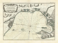
DESCRIPTION: A detailed view of Fort Louisbourg in Nova Scotia, Canada. From Bellin's "Le Petit Atlas Maritime Recueil de Cartes et de Plans des Quatre Parties du Monde". This atlas or pilot is a wonderful French produced small sized work that depicted many parts of the known world.
ADDITIONAL INFO:
CONDITION: Good condition with original color.
REFERENCE:


 Login / Register
 Basket