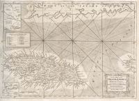
ARTIST: Thomas Kitchin
PUBLISHER: Published in the February 1760 issue of the London Magazine
MEDIUM: Copper plate engraving
DATE: 1760.
EDITION SIZE: Image size 7 1/8 x 10 1/8" (18 x 25.5 cm)
DESCRIPTION: Drawn from the best authorities. By Thos. Kitchin Geogr..<br><br> This map shows the Ganges River flowing through Bengal to Daca (Dhaka) and thence to its mouth at the Bay of Bengal. The map also shows the Little Ganges River. The southern region of Bengal is labeled "parts very little known.
ADDITIONAL INFO:
CONDITION: Fair condition. The right edge is trimmed into the neat line due to binding.
REFERENCE:


 Login / Register
 Basket