MEDIUM: Copper plate engraving
DATE: 1775
EDITION SIZE: Image size 19 x 26 1/8" (48.4 x 66.4 cm)
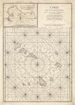
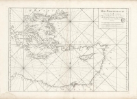
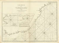
DESCRIPTION: A detailed chart of the Red Sea from Al Mukha to Jeddah. Gives soundings, islands and shoals etc. Inset charts are of Shake Omare, Goofs and Gedan. This map appeared in "Le Neptune oriental, dedie au roi /par M. d'Apres de Mannevillette. Paris / Brest.
ADDITIONAL INFO:
CONDITION: Good condition save for some soft creasing along upper centerfold. Several small opposing worm holes. B/W
REFERENCE:


 Login / Register
 Basket