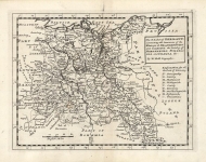
ARTIST: Hermann Moll
PUBLISHER: Printed & Sold by Tho. Bowles... John Bowles... .London
MEDIUM: Copper plate engraving,
DATE: c.1740.
EDITION SIZE: Image size 23 7/8 x 40" (66.5 x 10². cm) plus margins.
DESCRIPTION: A large scale and highly decorative map of Northern Italy..<br><br> This map is dedicated to King George II with royal arms. Inset views include a plan of the town and harbor of Leghorn. Eleven city plans are engraved along the right edge, they are Venice, Mantua, Milan, Turin, Genoa, Placenza, Parma, Modena, Florenza, (Florence) and Rome. It is also very detailed with many place names.
ADDITIONAL INFO:
CONDITION: Good condition save for some creasing along vertical fold lines. Some toning along right vertical crease. Original outline hand coloring.
REFERENCE:


 Login / Register
 Basket