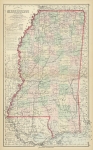
ARTIST: Frank Gray
PUBLISHER: Published in Philadelphia by O. W. Gray & Son.
MEDIUM: Handcolored stone engraving,
DATE: 1879.
EDITION SIZE: Image size 15 3/4 x 26 3/4" (400 x 680 mm) plus margins.
DESCRIPTION: This map appeared in "The National Atlas" Oklahoma is noted as Indian Territory and North and South Dakota is noted as one "Dakota". Railroad lines and major towns are noted. The inset in the lower left is "Territorial District of Alaska formerly Russian America."
ADDITIONAL INFO:
CONDITION: Good condition and color.
REFERENCE:


 Login / Register
 Basket