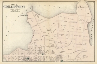
ARTIST: F. W. Beers
PUBLISHER: Published by Beers, Ellis and Soule. NY.
MEDIUM: Handcolored stone engraving,
DATE: 1867
EDITION SIZE: Image size 15 7/8 x 12 3/4" (403 x 324 mm) plus margins.
DESCRIPTION: A handsome map of this area that is now part of the Bronx. Included are the towns of Mt. Vernon, Tuckahoe and City Island. This map is from "Atlas of New York and Vicinity" by F. W. Beers. Early roads, outlines of homes, property lines and owners names are shown.
ADDITIONAL INFO:
CONDITION: Good condition save for occasional minor stain and or tear in the margins. Original handcoloring.
REFERENCE:


 Login / Register
 Basket

![Adams. [and] Hancock. [Towns of].](https://oldprintshop.com/uploads/jpg/24298_productthumb.jpg)