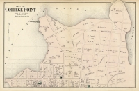
ARTIST: F. W. Beers
PUBLISHER: Published by Beers, Comstock & Cline, NY.
MEDIUM: Handcolored engraving,
DATE: 1873
EDITION SIZE: 13 3/4 x 21 1/2" (350 x 545 mm) plus margins.
DESCRIPTION: A detailed and nicely colored map from "Atlas of Long Island, New York. From recent and actual surveys and records." Many land owners names are given. This map shows an area from Stony Brook eastward to Wading River and the harbors of Smithtown, Port Jefferson and Mt. Sinai Harbor. The L.I. Rail Road is shown with named stations.
ADDITIONAL INFO:
CONDITION: Good condition with original handcolor.
REFERENCE:


 Login / Register
 Basket

![Adams. [and] Hancock. [Towns of].](https://oldprintshop.com/uploads/jpg/24298_productthumb.jpg)