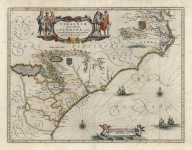
ARTIST: Willem Blaeu
PUBLISHER: Published by W. Blaeu, Amsterdam.
MEDIUM: Handcolored copper plate engraving,
DATE: c.1633.
EDITION SIZE: Image 15 5/8 x 20 11/16" (39.6 x 52.5 cm)
DESCRIPTION: This map was based upon Norwood's survey of 1618. The highly embellished cartouche features Neptune astride the royal coat of arms of England, trident in one hand and a galleon in the other. Below the map are twelve columns listing property owners. Many other engraved embellishments adorn this map. Willem Blaeu was appointed chartmaker to the East India Company in 1633. A beautiful map. <br><br>
ADDITIONAL INFO: Latin text on verso.
CONDITION: Good condition. Original handcoloring
REFERENCE: Palmer, "Maps of Bermuda" p.10.


 Login / Register
 Basket