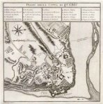
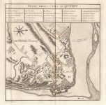
ARTIST: Gio. Tommaso Masi
MEDIUM: Copper plate engraving,
DATE: 1763.
EDITION SIZE: Image size, 7 x 10 1/4" (180 x 260 mm) plus margins.
DESCRIPTION: A fine early plan of Pensacola, Florida, from Masi's "Il Gazzettiere Americano." Published in Livorno, Italy. The map delineates the town and fortifications.
ADDITIONAL INFO:
CONDITION: Good condition. Black & white.
REFERENCE:


 Login / Register
 Basket