ARTIST: F. W. Beers
PUBLISHER: Published by Beers, Comstock & Cline. New York.
MEDIUM: Hand colored engraving.
DATE: 1873
EDITION SIZE: 15 1/2 x 11 7/8" (30.3 x 39.4 cm).
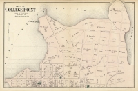
DESCRIPTION: A detailed and nicely colored map from "Atlas of Long Island, New York. From recent and actual surveys and records." Many land owners names are given. In 1898 this area became part of Queens County, New York City. Since 1833 this area has been a noted seaside resort. This map was published just one year after the Long Island Rail Road had extended its line to serve the Rockaways.
ADDITIONAL INFO:
CONDITION: Good condition and color.
REFERENCE:


 Login / Register
 Basket

![Adams. [and] Hancock. [Towns of].](https://oldprintshop.com/uploads/jpg/24298_productthumb.jpg)