ARTIST: Henri Chatelain
MEDIUM: Copper plate engraving,
DATE: 1719.
EDITION SIZE: Image size 31 x 55 1/2" (78.7 x 140.9 cm) plus margins.
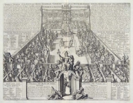
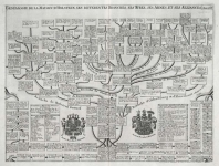
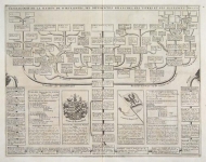
DESCRIPTION: A grand and beautifully engraved map of the Americas. This map is one of Chatelain's finest productions and shows both the complete Atlantic and Pacific Oceans and a large portion of Europe, Africa, and Asia. Richly embellished with numerous decorative vignettes and ornate cartouches that include illustrations of beavers at Niagara Falls; Native Americans hunting and fishing; the cod fishery; Strait of Gibraltar; Cape of Good Hope; two very involved cartouches on lower sheet with maps and city plans (Acapulco, Panama, mouth of Mississippi, Rio de Janeiro, Lima, Mexico City, Rio de la Plata, Havana, Vera Cruz, etc.), Native American customs (including Aztec pyramid and human sacrifice), costumed groups, sugar mill, mining, turtle fishing, flora and fauna; nine portrait medallions of explorers; inset of Islands of the Marianas; routes of explorers traced on map. This map appeared in Chatelain’s "Atlas Historique."
ADDITIONAL INFO: A beautiful impression.
CONDITION: Very good condition. Black & white.
REFERENCE:


 Login / Register
 Basket