ARTIST: John Ogilby
PUBLISHER: Published by Ogilby, White Fryers, London.
MEDIUM: Copper plate engraving
DATE: 1671
EDITION SIZE: Image size 17 1/4 x 21 1/2" (43.8 x 54.5 cm). plus margins.
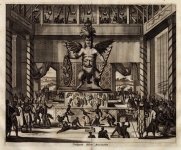
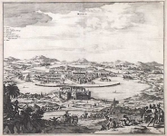
DESCRIPTION: This important map of the Americas comes from John Ogilby’s seminal atlas America: Being the Latest, and Most Accurate Description of the New World, published in London in 1671. Ogilby’s work is an English translation of Arnoldus Montanus’ Die Nieuwe en onbekende Weereld..., which was produced in Amsterdam earlier the same year. Considered the first encyclopedias of the Americas, both texts are richly illustrated with maps, views and portraits. With little exception, Ogilby’s work is a direct copy of Montanus’ atlas, which was illustrated throughout with derivates of previous classic maps and views. Ogilby did expand his atlas by adding fresh material on the English colonies, including an important map of the Americas and some of the earliest maps of Carolina, Maryland, Jamaica, and Barbados. Illustrated with over 122 magnificent engravings, Ogilby’s America was the most accurate compendium available of the New World. Cartographically, this map is based on Nicolas Visscher’s map of the same title, published in 1670 and dedicated to Cornelius Witsen. Although Ogilby follows Visscher’s outline he introduces some interesting changes. As in Visscher’s map, California is depicted as an island with a flat Northern coast, but Ogilby has changed the nomenclature. The maps have the same figured title piece and cartouche, but Ogilby’s map now enfolds the arms of Anthony Ashley, one of the Lords Proprietors of the Carolinas. Ogilby’s map makes many improvements to the east coast of North America and especially to the English colonies. He includes the towns of Boston, North London, and Millford, and changes New Amsterdam to New York. In comparison to Visscher’s map, Ogilby has added Maryland and Carolina and included the James, Barkly, and Ashley rivers. He has altered the placement of the great lakes and enclosed it at its western end.
ADDITIONAL INFO:
CONDITION: Overall in good condition. Some minor splits where it had been folded into text. Narrow margins. Professionally conserved.
REFERENCE: Tooley, "America" p. 121, no. 35; Schwartz & Ehrenberg, The Mapping of America p. 181.


 Login / Register
 Basket