ARTIST: John Ogilby
PUBLISHER: Published by Ogilby, White Fryers, London
MEDIUM: Copper plate engraving,
DATE: 1671
EDITION SIZE: 11 1/4 x 13 1/2" (285 x 345 mm) plus wide margins.
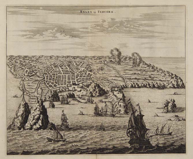
DESCRIPTION: This magnificent bird's-eye view of Angra on Terceira in the Azores, is a reduced image of the view published in Jan Huygen van Linschoten’s Itinerario. The map was first reproduced by Johann Theodore de Bry in 1601 to illustrate the account of Van Linschoten’s travels in De Bry's Minor Voyages. The Azores was first discovered in 1439 by Prince Henry the Navigato and was initially colonized by the Portuguese. Its strategic location played an invaluable role in the expansion of the Portuguese empire, and the Azores served as an important port of call for Portuguese vessels traveling to South America, Africa, and the Orient. The layout and fortification of the city are carefully recorded in this detailed plan as is the abundant farmlands surrounding the city. Great attention is paid to the placement and fortification of the harbor, which would have been one of the most important assets of this trade route island. Located in between a shallow sandy outcrop and the fort of San Sabastian, the harbor is well protected from both treacherous weather and invading ships. This important view comes from John Ogilby’s seminal atlas, "America: Being the Latest, and Most Accurate Description of the New World," published in London in 1671. Ogilby’s work is an English translation of Arnoldus Montanus’ "Die Nieuwe en onbekende Weereld. . . ," which was produced in Amsterdam earlier the same year. Considered the first encyclopedias of the Americas, both texts are richly illustrated with maps, views and portraits. With little exception, Ogilby’s work is a direct copy of Montanus’ atlas, which was illustrated throughout with derivatives of previous classic maps and views. Ogilby did expand his atlas by adding fresh material on the English colonies.
ADDITIONAL INFO:
CONDITION: Good condition. Black & white.
REFERENCE:


 Login / Register
 Basket