ARTIST: John Ogilby
MEDIUM: Copper plate engraving,
DATE: 1671.
EDITION SIZE: 11 1/4 x 14 1/8" (283 x 360 mm) plus margins.
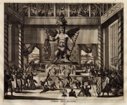
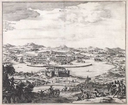
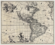
DESCRIPTION: The general outline of South America was fairly well known to cartographers and mapmakers by the end of the sixteenth century. Following Magellan’s momentous voyage around the southern tip of South America, both the eastern and western coasts of the continent were extensively explored. A wealth of maps were produced by European publishers depicting the individual regions in South America, as well as the continent as a whole. This decorative chart is a derivative map based on a sequence of maps published by the major European map houses. Oriented with North to the left, the map depicts the major portion of Chile that lies between 25 and 45 degrees South latitude. The Andes are shown in profile and most of the major bays are identified by name. Although the outline is copied from Blaeu and Hondius, Ogilby has added an ornate cartouche that fills most of the upper section of the map and makes up for the lack of geographical knowledge about the region. This map appeared in John Ogilby’s seminal atlas "America: Being the Latest, and Most Accurate Description of the New World," published in London in 1671. Ogilby’s work is an English translation of Arnoldus Montanus’ "Die Nieuwe en onbekende Weereld. . . ," which was produced in Amsterdam earlier the same year. Considered the first encyclopedias of the Americas, both texts are richly illustrated with maps, views, and portraits. With little exception, Ogilby’s work is a direct copy of Montanus’ atlas. Ogilby did expand his atlas by adding fresh material on the English colonies. Illustrated with over 122 magnificent engravings, Ogilby’s America was the most accurate compendium available of the New World.
ADDITIONAL INFO:
CONDITION: Good condition, black and white. Some creasing in upper and side margins.
REFERENCE:


 Login / Register
 Basket