ARTIST: J. F. W. Des Barres
PUBLISHER: Published by J. F. W. Des Barres Esq. May 19, 1779.
MEDIUM: Aquatint and line engraving,
DATE: 1779
EDITION SIZE: Image size 31 x 23 1/4" (79 x 59 cm) plus margins.
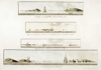
DESCRIPTION: This scarce chart shows the entrance to New York Harbor from Sandy Hook northward to Mid-Manhattan. Named on this chart is Coney Island, Gravesend Bay, the Narrows, Staten Island, Brookland (Brooklyn) and New York Island (Manhattan). Many soundings are noted with shoals and mud flats. Two inset views are shown, "Bond Hollow bearing S.b.E." and "Mount Pleasant half way between the Cedars on the Hook & the Light House." This chart is from the "Atlantic Neptune" by Captain Joseph Frederick Wallet Des Barres. It is one of the finest large-scale sea atlases of the United States and Canadian Atlantic coastline ever produced. The maps in the atlas were produced over a six-year period (1775-81) and are well known for their accurate portrayals of various sounds, bays, bars, and harbors, as well as navigational hazards. This atlas was used extensively by the Royal Navy during the American Revolution.
ADDITIONAL INFO:
CONDITION: Fair to good condition. Trimmed to right neatline with some areas of loss in the extreme lower right corner. Original coloring with modern enhancements.
REFERENCE:


 Login / Register
 Basket