ARTIST: Henri Chatelain
PUBLISHER: Published in Amsterdam by L’Honore & Chatelain.
MEDIUM: Copper plate engraving printed on fine laid paper,
DATE: 1714
EDITION SIZE: 14 x 8 3/8" (356 x 213 mm) plus margins.
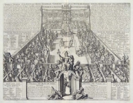
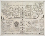
DESCRIPTION: This impressive engraving is the eleventh plate in volume four of Chatelain’s celebrated encyclopedia, Atlas Historique. Printed in 1714, this unique engraving is from the first edition of volume four published by Chatelain as part of his large seven volume work. This fascinating sheet is one of a series of engravings from this atlas demonstrating the lifestyle and customs of the Lapps. The sheet includes an inset map of Lapland covering all of Sweden around the Gulf of Bothnia. A series of small vignettes in the lower section of the plate depicts the customs of the Lapps, their nomadic existence and their favorite pastimes. This decorative sheet is a wonderful example from Chatelain’s celebrated text.
ADDITIONAL INFO:
CONDITION: Very good condition. Black and white.
REFERENCE: Phillips, A List of Geographical Atlases in the Library of Congress, 305, 548, & 579; Moreland & Bannister, Antique Maps; Koeman, Atlantes Neerlandici, vol. II. p. 33-38.


 Login / Register
 Basket