ARTIST: Henri Chatelain
PUBLISHER: Published in Amsterdam by L’Honore & Chatelain.
MEDIUM: Copper plate engraving printed on fine laid paper,
DATE: 1720
EDITION SIZE: 13 7/8 x 19" (353 x 483 mm ) plus margins.
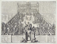
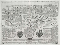
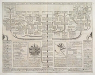
DESCRIPTION: This impressive engraving is a wonderful example of Chatelain’s elegant plates. Included in the 1720 edition of Atlas Historique, published by Chatelain in Amsterdam, this large chart is the twenty-first plate in volume three. This impressive sheet provides the history of various cities and regions allied with Switzerland at the beginning of the eighteenth century. The top section of the sheet is adorned with nine inset maps of the various regions, including a plan of Geneva and a large map of Switzerland. During the sixteenth century, the Swiss Confederation was composed of thirteen self-governed states. Though they were technically part of the Holy Roman Empire, they had become almost completely liberated when the Swiss defeated Emperor Maximillian in 1499. With them were connected by purchase, or conquest, or free consent, the adjoining lands of Aargau, Thurgau, Wallis, Geneva, Graubündten (Grisons, Rhätia), and the princedom of Neuchatel and Valangin. This informative sheet provides a history of all these regions and a note regarding their location. This impressive chart is a wonderful example of Chatelain’s superb work and a fascinating record of Swiss history.
ADDITIONAL INFO:
CONDITION: Very good condition. Black and white.
REFERENCE: Phillips, A List of Geographical Atlases in the Library of Congress, 305, 548, & 579; Moreland & Bannister, Antique Maps; Koeman, Atlantes Neerlandici, vol. II. p. 33-38.


 Login / Register
 Basket