ARTIST: Henri Chatelain
PUBLISHER: Published in Amsterdam by L’Honore & Chatelain.
MEDIUM: Copper plate engraving printed on fine laid paper,
DATE: 1720
EDITION SIZE: 13 7/8 x 17 7/8" (353 x 455 mm) plus margins.
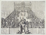
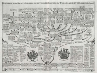
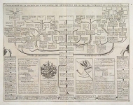
DESCRIPTION: This impressive engraving is a wonderful example of Chatelain’s elegant plates. Included in the 1720 edition of Atlas Historique, published by Chatelain in Amsterdam, this large chart is the eighteenth plate in volume three. This engraving provides a detailed account of Swiss history, as well as an impressive inset map of ancient Switzerland. The sheet pays particular attention to the formation of the Swiss state and to the legend of the Swiss patriot William Tell. According to folklore, Tell was a native of Uri, one of the Swiss forest cantons. Gessler, the canton's Austrian bailiff, decreed that Swiss citizens must remove their hats before his hat, which he had posted on a stake in the town center. In an act of defiance, Tell refused to remove his hat, and as punishment was ordered to shoot an apple off the top of his small son's head. Although he accomplished the feat, he was held prisoner by Gessler after revealing that he planned to kill the bailiff with a concealed arrow. Tell escaped and eventually shot Gessler on the mountainside near Kussnacht, thus inspiring widespread revolt across Switzerland. Although there is no valid proof of Tell’s existence, the legend is based on the history of the “Everlasting League” which decisively defeated the Hapsburgs in 1388 and established Switzerland as an independent country. The bottom of the sheet is adorned with a series of vignettes depicting the legend of William Tell. A numbered key identifies the specific events illustrated in the images. Various tables as well as the lengthy historical notes make this impressive engraving a wonderful example of Chatelain’s superb work.
ADDITIONAL INFO:
CONDITION: Very good condition with the exception of a skillfully mended tear extending from the center fold. Black and white.
REFERENCE: Phillips, A List of Geographical Atlases in the Library of Congress, 305, 548, & 579; Moreland & Bannister, Antique Maps; Koeman, Atlantes Neerlandici, vol. II. p. 33-38.


 Login / Register
 Basket