ARTIST: Henri Chatelain
PUBLISHER: Published in Amsterdam by L’Honore & Chatelain.
MEDIUM: Copper plate engraving printed on fine laid paper,
DATE: 1720
EDITION SIZE: 15 x 18 5/8" (382 x 473 mm) plus margins.
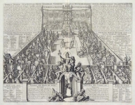
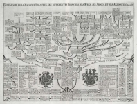
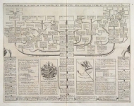
DESCRIPTION: This impressive map is a wonderful example of Chatelain’s elegant charts. Included in the 1720 edition of Atlas Historique, published by Chatelain in Amsterdam, this large chart is the twenty-eighth plate in volume two. This sheet includes a large map of the Habsburg Empire, which covers most of Austria including the northern tip of the Gulf of Venice. The sheet also includes two smaller inset maps showing the principal Habsburg regions. Two armorial crests and a small perspective view are also incorporated. The top section of the sheet is occupied with a large table identifying the regional chancelleries of the time. This fine map is a wonderful example from Chatelain’s important text. By combining a wealth of information and geographical observation, with delicate engraving and an uncomplicated composition, this elegant map is a quintessential example from the golden age of French mapmaking.
ADDITIONAL INFO:
CONDITION: Good condition. Black and white.
REFERENCE: Phillips, A List of Geographical Atlases in the Library of Congress, 305, 548, & 579; Moreland & Bannister, Antique Maps; Koeman, Atlantes Neerlandici, vol. II. p. 33-38.


 Login / Register
 Basket