ARTIST: Henri Chatelain
PUBLISHER: Published in Amsterdam by L’Honore & Chatelain.
MEDIUM: Copper plate engraving printed on fine laid paper,
DATE: 1720
EDITION SIZE: 18 1/2 x 23 5/8" (470 x 600 mm) plus margins.
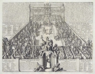
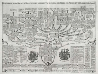
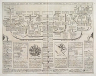
DESCRIPTION: This impressive map is a wonderful example of Chatelain’s elegant charts. Included in the 1720 edition of Atlas Historique, published by Chatelain in Amsterdam, this large chart is the twenty-third plate in volume two. This striking map of Germany covers the whole of the country and identifies the principal regions ruled by every German Prince. The map is flanked by two tables connecting the various princes with specific locations across the map. This fine map is a wonderful example from Chatelain’s important text. By combining a wealth of information and geographical observation, with delicate engraving and an uncomplicated composition, this elegant map is a quintessential example from the golden age of French mapmaking.
ADDITIONAL INFO:
CONDITION: Fair condition with the exception of a small tear in corner crease in the bottom right corner. Tape residue in bottom section of sheet. Creases in sheet where it has been folded to fit into atlas. Black and white.
REFERENCE: Phillips, A List of Geographical Atlases in the Library of Congress, 305, 548, & 579; Moreland & Bannister, Antique Maps; Koeman, Atlantes Neerlandici, vol. II. p. 33-38.


 Login / Register
 Basket