ARTIST: Henri Chatelain
PUBLISHER: Published in Amsterdam by Lâ??Honore & Chatelain.
MEDIUM: Copper plate engraving printed on fine laid paper,
DATE: 1720
EDITION SIZE: 13 5/8 x 17 5/8" (347 x 448 mm) plus margins.
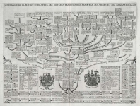
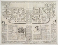
DESCRIPTION: This impressive map is a wonderful example of Chatelain’s elegant charts. Included in the 1720 edition of Atlas Historique, published by Chatelain in Amsterdam, this large chart is the sixth plate in volume two. This striking map of Europe stretches from northern Africa to the Baltic Sea. It shows the locations of various royal dynasties including the Goths, the Lombards, the Ostrogoths, and the Visigoths, as well as the kings of France, Italy, and Spain. Numerous keys identify the principal towns and states and a lengthy set of tables list all the various European kings in chronological order. This fine map is a wonderful example from Chatelain’s important text. By combining a wealth of information and geographical observation, with delicate engraving and an uncomplicated composition, this elegant map is a superb example from the golden age of French mapmaking.
ADDITIONAL INFO:
CONDITION: Good condition. Black and white.
REFERENCE: Phillips, A List of Geographical Atlases in the Library of Congress, 305, 548, & 579; Moreland & Bannister, Antique Maps; Koeman, Atlantes Neerlandici, vol. II. p. 33-38.


 Login / Register
 Basket