ARTIST: Henri Chatelain
PUBLISHER: Published in Amsterdam by L’Honore & Chatelain.
MEDIUM: Copper plate engraving printed on fine laid paper,
DATE: 1721
EDITION SIZE: 13 1/4 x 17 1/8" (337 x 435 mm) plus wide margins.
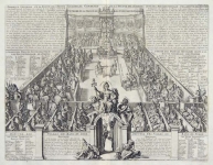
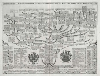
DESCRIPTION: This handsome genealogical chart is a wonderful example of Chatelain’s elegant engravings. Included in the 1721 edition of Atlas Historique, published by Chatelain in Amsterdam, this large sheet is the forty-first illustration in volume one. This highly detailed plate charts the genealogy of the ruling families of Europe who were allied with Holland at the beginning of the eighteenth century. Highly decorative, this impressive genealogical tree is adorned with numerous portrait busts and a lengthy historical text. This fine plate is a wonderful example from Chatelain’s important text.
ADDITIONAL INFO:
CONDITION: Good condition. Black and white.
REFERENCE: Phillips, A List of Geographical Atlases in the Library of Congress, 305, 548, & 579; Moreland & Bannister, Antique Maps; Koeman, Atlantes Neerlandici, vol. II. p. 33-38.


 Login / Register
 Basket