ARTIST: George Eldridge
PUBLISHER: Authorized and Published by Geo. W. Eldridge, Boston, Mass. Charles C. Hutchinson 152 State St. Boston. General Agent.
MEDIUM: Lithograph,
DATE: 1904.
EDITION SIZE: Two sheet map, joined. 26 1/2 x 47 1/2" plus margins.
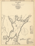
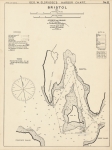
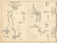
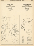
DESCRIPTION: A very large linen-backed chart from Eldridge's series of “lettered” charts that covered the northeastern coast from New York to Maine. This chart covers the area from Amaganset, Gardiner’s Island and New London eastward to Gay Head on Martha’s Vineyard with Block Island centrally located. This chart is highly detailed with hundreds of soundings, locations, types of buoys, three light ships, bottom type, tidal information, reefs, shoals and anchorage’s. Just about everything a mariner could use these waters. An inset map is of Block Island Harbor (now called Old Harbor.) These large scare nautical charts are generally rare on the market today. Although many were produced, the environment and manner in which they were used usually destroyed them. George Washington Eldridge (1845-1912) took over the business from his father George Eldridge (1821-1900). A scarce chart.
ADDITIONAL INFO:
CONDITION: Overall good condition for a working sea chart of the period. Time toning and damp staining in areas of the paper. Original coloring on channel buoys and lightships.
REFERENCE:


 Login / Register
 Basket