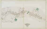
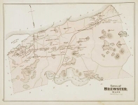
ARTIST: George Walker
PUBLISHER: Published Geo. H. Walker & Co. 160 Tremont St. Boston.
MEDIUM: Multi-stone lithograph,
DATE: 1891
EDITION SIZE: 17 1/2 x 26" (44.5 x 66.1 cm) plus margins.
DESCRIPTION: A map of the region from the "Atlas of Massachusetts compiled under the direction of O.W. Walker, C.E." The Walker Co. was formed in 1880 by George Hiram Walker and his brother Oscar. They were very prolific, publishing maps, atlases and bird's eye views of New England locales. The Walkers were the last of Boston's important lithographers.
ADDITIONAL INFO:
CONDITION: Good condition and color.
REFERENCE:


 Login / Register
 Basket

![Village of Hyannis [and] Town of Barnstable. Village of Hyannis Port including Sea Shore Lots of the Hyannis Land Company.](https://oldprintshop.com/uploads/jpg/43962_productthumb.jpg)